About GPSで面積
This app calculates the area and distance based on the latitude and longitude obtained from GPS. When you want to find out the area, walk around the perimeter on site and mark when you come to a corner. When you reach the...
This app calculates the area and distance based on the latitude and longitude obtained from GPS.
When you want to find out the area, walk around the perimeter on site and mark when you come to a corner.
When you reach the final corner, calculate the area enclosed by the marker.
It can be used to measure the area of land, buildings, etc., and the distance of routes, walking, golf, etc.
Basic usage
1. Press the "Mark at current location" button to add a marker at your current location.
2. Every time you add a marker, a line is drawn and the distance is displayed.
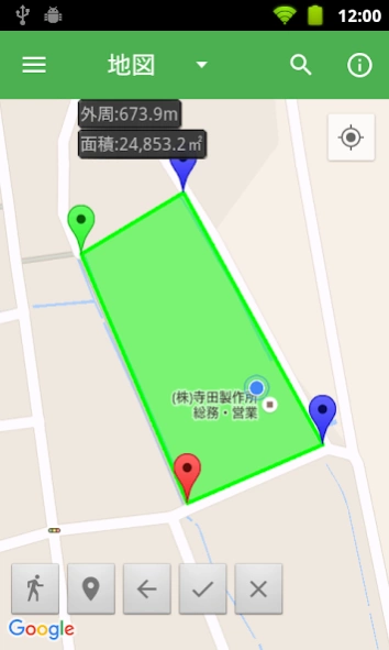
3. Click the "Calculate area" button to display the area surrounded by markers.
The distance at this time will be the perimeter of the selected area.
*Area is not displayed correctly in areas where lines intersect.
* You can mark up to 500 markers.
Detailed usage
・From the left, the buttons on the bottom left are "Tracking", "Mark current location", "Clear one", "Calculate area", and "Clear all".
・Start tracking with the "Tracking" button.
・A marker will be added to your current location at regular intervals until you press the "Tracking" button again.
・Add a marker to your current location with the "Mark at current location" button.
・Clear the last marked marker with the "Clear One" button.
- Display the area and perimeter of the area surrounded by markers with the "Calculate area" button.
・The start point (green) and end point (red) do not need to be connected. Add it as the last edge when calculating the area.
- Clear all markers and area areas with the "Clear All" button.
・You can change the unit of area and the unit of distance with the menu button.
・Usable area units
square meters, square kilometers, square mm, ares, hectares, square feet, square yards, acres, square miles,
Tsubo, Ridge, Tan, Machi, Tokyo Dome
・Usable distance
m, km, feet, yards, miles, between, towns, ri
- Related units can be automatically converted to the most suitable unit.
・Automatic unit conversion can be enabled or disabled with the option "Automatic unit adjustment".
・You can save the marker displayed on the screen with the menu button.
- You can call the saved marker with the menu button.
- You can search by entering the place name, address, name with the search button.
Also, since Google maps are displayed on the screen, you can calculate the area simply by marking it on the map.
・The operation of the map conforms to Google maps.
・ Add a marker to the location by long tapping the map.
・Tap the marker to display the marker number and latitude and longitude.
- Long tap the marker and drag to move the marker.
・The map can be switched between "Map", "Aerial Photo", and "Terrain".
*The area is calculated as the area of a sphere surrounded by geodesics, with the earth as a sphere of 6,378,137m.
It does not take into account altitude, slope, etc.
*Distance is obtained from Google maps API after considering geodesic curves.
* Since the accuracy of GPS depends on the terminal, if you are concerned about the position acquired,
Please respond by moving the marker.
_/_/_/_/_/ End of support for Android less than 5.0 _/_/_/_/_/
Thank you for using "Area by GPS".
We have important information for customers using the Android app.
We have decided to end support for devices with Android 5.0 or lower.
If your device's OS is less than 5.0, you will not be able to update to the latest version.
・How to check the OS version
"Settings - Device information - Android version"
Support will be discontinued, but installed apps will continue to work.
If you have any questions, please contact us from our website.
We apologize for any inconvenience this may cause, and appreciate your understanding.
Previous Versions
Here you can find the changelog of GPSで面積 since it was posted on our website on 2023-04-01 14:11:25.
The latest version is 1.2024.0226 and it was updated on 2024-04-22 12:14:07. See below the changes in each version.
GPSで面積 version 1.2024.0226
Updated At: 2024-02-25
Changes: Ver.1.2024.0226
・調整を行いました。
GPSで面積 version 1.2023.0822
Updated At: 2023-08-21
Changes: Ver.1.2023.0822
・調整を行いました。
GPSで面積 version 1.2023.0502
Updated At: 2023-05-02
Changes: Ver.1.2023.0502
・GPSから現在地を取得できなかった不具合を修正しました。
・その他、調整を行いました。
GPSで面積 version 1.2020.0901
Updated At: 2020-08-31
Changes: Ver.1.2020.0901
・Android10にて動作確認を行いました。
・登録された一覧に面積、または、距離を表示するように変更しました。
・その他、調整を行いました。